 The Hochkopf is a mountain on 1267 m above sea level, located between Todtmoos and Todtnau in the southern Black Forest.
A detour to the Hochkopf with its viewing tower is well worthwhile if you are hiking around Todtmoos and Todtnau. The easiest way to reach it is from the Weißenbachsattel parking area for hikers between Todtnau-Präg, Herrenschwand and Todtmoos-Weg. From there it is 1.8 km to the summit with a height difference of just under 200 metres.
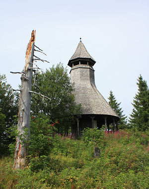
The Hochkopf Tower with its distinctive form offers a magnificent view over the surrounding valleys and mountains, including the Feldberg, Herzogenhorn, Schauinsland and Belchen. In addition, a glorious Alpine panorama unfolds in fine weather.
Photos: Hochkopf look-out tower and a nice view on Präg near Todtnau
 A very special event took place once again this year in the small community of Dachsberg in the southern Black Forest: the Dachsberger Charcoal Pile Festival. The charcoal pile at the forest sports ground in the district of Wolpadingen smoked from the 25th July to the 9th August 2009, and a great deal of entertainment was on offer at the same time.
The Markgräfler Bergturnfest gymnastic festival and the jubilee weekend of the Dachsberg traditional costume band with its regional music festival had already taken place on the first two weekends. The climax was the folklore day on Sunday the 9th of August with plenty of music, a national park market and demonstrations of old Black Forest handicraft trades. The charcoal pile will be opened on 21st/22nd August, and the charcoal offered for sale on 22nd August.
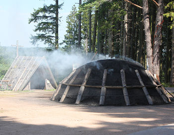
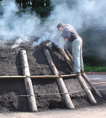
In the Dachsberg charcoal pile, charcoal is produced in the traditional manner from approximately 20 steres (cubic metres) of beechwood in approx. 4 weeks (2 weeks just for cooling). The charcoal stack is watched around the clock by the charburners during this time (the shelter can be seen on the left in the top picture, the charburner is clearing the smoke holes in the bottom picture). The charburners also enjoy answering visitors' questions and providing expert information about the composition of the charcoal pile and the history of charcoal burning in the Black Forest.
 Charcoal burning was an important industry in the Black Forest for a long time. The charcoal was mainly required for ironworks and glass manufacture. Increasingly larger quantities were needed, which meant that vast areas of the Black Forest were bare and not covered by dense forest as they are today. Coal was increasingly used in industry from the 18th century, so that the trees grew back and the forest could recover.
Incidentally, the community of Dachsberg is set in a beautiful location on a plateau in the Hotzenwald Forest, the southernmost part of the Black Forest. Well-known places in the area include St. Blasien and Todtmoos. Lake Schluchsee, Lake Titisee and Feldberg Mountain are also not far away.
A wonderful way of getting to know the Black Forest is a hike along the 'Schluchtensteig', a hiking trail in the southern Black Forest. This trail was not opened until 2008 but is already one of the most popular hiking trails in the Black Forest.
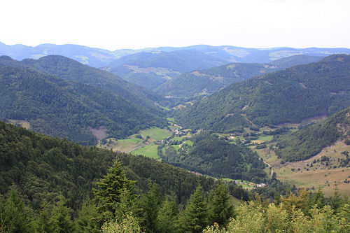
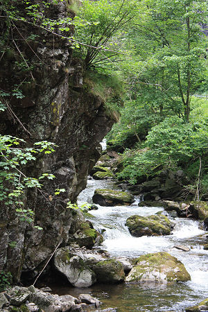
The Schluchtensteig crosses the South Black Forest regional park along the southern edge of the Black Forest. It not only takes in the impressive gorges of the Wutach, Gutach, Rötenbach, Haslach and Wehra (photo) but also regularly ascends to mountain tops and other lookout points which provide a view of the gorges below and the mountains of the High Black Forest and the Swiss Alps. The trail also runs past Lake Schluchsee, the largest lake in the Black Forest. The high plateaus around the villages of Dachsberg and Ibach present an interesting contrast.
The Schluchtensteig is not a footpath, it often runs over narrow trails, over rough and smooth and sometimes up steep tracks and ladders. It is therefore advisable to wear good quality hiking shoes. The hiking trail is passable from May to approx. November. Hiking on the Schluchtensteig is not recommended with snow and ice.
Anyone who wants to hike over the full length of the trail can divide it up into six stages of approximately 20 km each. Needless to say, shorter sections can also be tackled depending on the available time and fitness.
Places along the Schluchtensteig